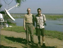
A day before the eclipse at the exact of the eclipse.
My prediction is verified as Zane and I stand in the sunlight.
The Exploratorium sent me to the total solar eclipse in Zambia to teach at local schools, help write dispatches from the field, and to be the "talent" on the webcast of the eclipse. However, experimental physicists are general problem solvers, so when problems developed that I was pleased to be able to help the team solve them.
Problem 1, Where will the sun be?
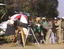
We arrived at Sausage Tree Camp just after sunset. The next morning, we needed to select a site from which to photograph the eclipse. We would have to place the satellite dish, build a television studio, and mark out a place in the sun for Zane Vella and I. The site had plenty of trees, so we needed to select the best clearing.
We had a table from Fred Espenak which listed the altitude and azimuth of the sun at first, second, third and fourth contact. I had a compass to measure azimuth and my handy measuring tool ( my hand actually) to measure elevation. A hand span at arms length is 20 degrees and a fist at arms length is 10 degrees. The team brought me to three clearings and I showed them my predicted path of the sun through each clearing during the eclipse. From my data we selected a site right on the banks of the Zambezi River.
A lot of people were going to do a lot of work to set up the site, so I wanted to be right. The satellite engineers loaned me their precision compass and inclinometer and I checked out my original estimates. The site looked good. It was the day before the eclipse so my prediction would be verified by the motion of the sun this very afternoon.
One day before the eclipse at the time of the eclipse I stood in the clearing to check out my prediction. The sun moved across the sky just where I predicted.
Whew!
Tomorrow we would view the eclipse.
Problem 2 Where is the South cellestial pole?
Larry and Aron had three great telescopes, but the telescopes weren't tracking the sun correctly, they asked for help. I whipped out my compass and even a quick look showed that the telescopes axes were not correctly aligned.
The axis of the telescopes had to point to the south cellestial pole. Where was it now as we set up the telescopes in the middle of the day?
When I moved the compass toward the telescopes there was a worry that the steel of the telescope mounts and the magnets in the drive motors might deflect the reading. In adition I would have to correct for a 4 degree westward deviation in the magnetic field at this location in Zambia.
Once again the satellite engineers loaned us a precision compass, I then grabbed a string and stretched the string using the compass along a true north-south line. The string let me hold the compass far from the metal and motors of the telescope. We set the elevation to match our latitude and checked the tracking of the sun.... it was right on.
That night we looked for the south cellestial pole in the sky. The milky way stetched bight and beautiful from horizon to horizon. The southern cross and the bright pair of stars alpha and beta centaurus provided guides to the south pole location. It made me glad I live in the northern hemishere where polaris provides such a great beacon for finding the pole.
By the way, I found the magnitude of the magnetic deviation in two places, on a topographic map of the park, and also in the memory of the GPS unit brought by Lowell.
Problem 3 What time is it?
We needed to know the time precisely not only for the eclipse but also to make contact with the satellite. In the city we could have dialed a "time-of-day" service, throughout the US we could tune in to the time service radio broadcast of WWV, neither of these services was available in the African bush. However, there is one great time reference available all over the earth, the GPS satellite system.
Lowell brought his GPS receiver. The GPS system is based on an array of satellites which each contain an atomic clock. The receiver units pick up radio signals from the GPS satellites and then calculate latitude, longitude, altitude and time. In order to find positions accurate to 100 feet the GPS receiver must calculate the time to within 100 nanoseconds. Thus the time displayed on the GPS is certainly good to the second. I used Lowell's GPS to set my watch to the nearest second, and then other people set their watches from mine.
Later in the morning, Dave borrowed my watch and used it to broadcast the correct time over his radio to other observers throughout Lower Zambezi National Park.
Go to Are the Rays Real
|
Scientific Explorations with Paul Doherty |
|
1 July 2001 |