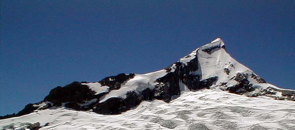
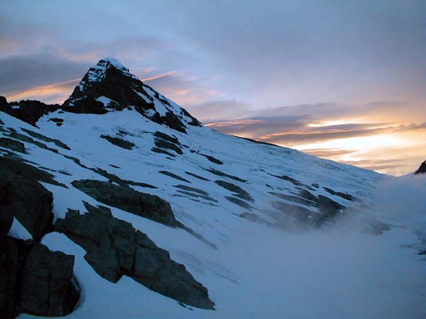
Mt. Aspiring, the snowy ramp leads up to the NW ridge, the left skyline.
Jan 20,2002
"The Matterhorn of the South," that's what Mt. Aspiring is called. Its glacier-carved icy summit pierces the sky like an arrow. I wanted to climb a peak in New Zealand so I chose to climb the most beautiful one. I invited many of my friends but only Bob Ayers joined me.
The climb is spectacular and not easy, the easiest route, the northwest ridge, is New Zealand grade 2+ on a scale where grade 3 requires using two ice tools and front points plus snow and ice belays. Grade 3 is just beyond my current level of ability on ice. So Bob and I decided to go with a guide from Adventure Consultants. This was the first time in over 30 years of climbing that I ever hired a guide. This was also the first time I paid to fly in a helicopter to a mountain climb. Our plan was that since New Zealand weather changes rapidly, we could fly in to the mountain during a short spell of good weather, climb the peak and then hike out.
We stopped by the DOC, Department of Conservation, office in Wanaka and noticed the Mount Aspiring poster on the wall, one variation on our route called "the ramp" was cross hatched. A note added,"Warning, several climbers have died on the ramp." They suggested other variations to the route. That seemed like a good idea to me.
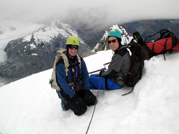
We met our guide Bryan Moore at Adventure Consultants headquarters in Wanaka. He is a mountain guide with worldwide experience and also the mountain course instructor at the local college. He was extremely knowledgeable about all aspects of climbing. I also noted that he was fit.
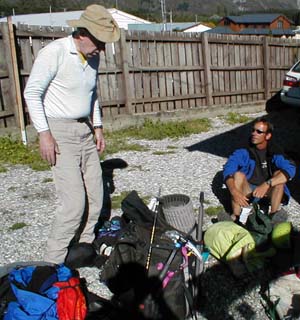
The weather looked good so we decided to fly in ASAP, this meant that we moved right to business as Bryan inspected our gear. As Bob said, "we passed." We had all the gear we needed. Looking at our stuff I could see it was well used but not worn out, just like our bodies.
We were running a bit late for our helicopter rendezvous so we stepped out of Bryan's car, put on our plastic boots, grabbed our gear and headed to the landing pad just as the helo arrived. The pilot, Charlie, was a local farmer who loved flying and provided helicopter service to climbers. As we lifted off I wondered if, in our rush, we had forgotten anything important, I didn't linger on that thought long as my attention was drawn to glacier draped mountains including Mt. Aspiring. Its summit might reach a mere 3030 meters, nearly 10,000 feet, but it did so from sea level! We flew down the Matukituki river valley climbing all the time, passing a mountain hut on a ridge top and landing at Bevan Col. We looked out across the Bonar glacier at Mt. Aspiring. The mountain was as awesome as we expected. Our first job was obvious, cross the glacier to the Colin Todd hut at the base of the Northwest Ridge.
We shouldered our packs, heavy with the extra weight of ice axe, ice hammer and snow stakes, and hiked down to the glacier. There we stopped to don crampons and to rope up. Not surprisingly Bryan had us use the kiwi coil technique. I had read about this technique but never used it before. Bryan and Bob tied in at the ends of the rope, then they coiled their ropes until they were each 8 meters from me in the middle. We also preattached prusiks to the rope. All of this was to protect us in case one of us should fall into a crevasse, the rope would stop the fall then the rope from the coils could be used during the rescue as the fallen climber prusiked up out of the crevasse.
The bright sunny day meant that it was hot on the glacier, and wet. Bryan chose a good route and we never stepped into any puddles that were deeper than our plastic boots. At the far side of the glacier Bryan short-roped us up a section of front pointing that led to the hut. On later trips over this same section he let us climb without using a short rope, he explained to us that the first time we climbed it he hadn't figured out our climbing abilities yet.
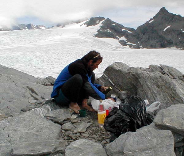
The hut had beds for 12 and it was full, so Bryan suggested we bivy out on the rocks. Luckily for me, who had brought minimalist bivy gear, there were perfect flat soft places among the rocks. I chose one a bit down hill from Bob and Bryan. I also appreciated that on a guided trip the guide cooked dinners, what a treat. We were in bed at 9 PM, long before dark aiming to get up by 3:30 AM and hit the trail by 4 AM. The plan for the morning was to climb the "kangaroo variation" which is mostly rock scrambling.
After a great sleep and the occasional view of the southern hemisphere Milky Way and Magellanic Clouds, I awoke precisely at 3:30 AM. I heard the clank of climbing gear nearby and so assumed that Bob and Bryan were also getting ready. I packed and donned my full mountain gear and hiked uphill only to find darkness, my partners were still asleep. I woke them up and Bryan moved like lightning, he was up dressed, ready to go with water boiling in no time flat. I was impressed. Even so we didn't hit the ice until 5 AM, about an hour behind the plan. We stopped to put on crampons and to rope up, I got to go on the end of the rope this time. We hiked across the glacier in the dark watching the pools of light move above us and below us as other parties headed to the mountain. The sight of yellow lights strung up the side of a mountain is one of the most wonder full sights in all of mountaineering, the mountain seems to be dressed up in moving Christmas lights.
As we hiked Bryan suggested that we climb the ramp route to save time, we agreed. I asked about the warning at the DOC, he said that those were beginning climbers who were descending the slushy Ramp troute without belays in the afternoon when one fell and pulled the others down the mountain. We would ascend, but not descend the ramp and we would belay.
As usual the transition from ice to rock at the bottom of the ramp was tricky, I ended up chimneying with my back on rock and my crampons on ice. Two belayed rock pitches followed, then we moved onto the ice.
Bryan tied us in 3 meters apart at the end of the rope. He free soloed up 60 meters and put in protection, usually a snow stake. Then belayed us as we climbed up. Bob and I are experienced climbers and so went all out to climb as fast as possible on each pitch knowing we could catch our breath while Bryan led the next pitch. When we arrived at each belay we clipped in, I handed Bryan my snow stake, and sent him on again. Our years of experience with roped belays showed up on these first 10 pitches of climbing so we wasted little time. Bryan smiled as we passed another party that had left camp an hour before us (They were the party I had heard clanking about.). The climbing was at an angle that allowed us to use all 10 points on the crampons.
Look at the picture of the mountain again and notice the ramp, it is twelve, 60 meter pitches long. This is a big mountain. The ramp steepened for the last two pitches, so that we had to use the front points on our crampons and use our ice axes in the snow dagger position. Luckily the snow was in good crisp styrofoam condition, not too hard and not to soft, so the climbing was relatively straightforward. When we reached the ridge we took a break for snacks. At the ridge we caught up with two other parties on the ridge who had started an hour before we did.
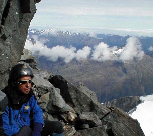
We continued to the summit, roped up but without the need to belay. The final summit ridge was spectacular, footprints led across steep waves of snow to the summit. The image reminded me of photographs taken near the summit of Everest, except that here the air was much thicker. When we arrived at the summit, we were alone.It was 1 PM and the clouds were racing by just barely over our heads. The views of the deep glacial valleys, the glaciers and spectacular waterfalls were stunning. The weather was warm too, it was the first time Bryan had ever been able to wear shorts and long underwear to the summit without wearing windpants over them.
While we enjoyed the summit, the cloud layer was getting lower, so we decided to head down quickly. When we reached the top of the ramp Bryan led us down the rocky ridge instead.The ridge was easy class 3 scrambling, but you would be seriously injured if you fell. We did 4 rapells and managed to keep ahead of one other descending party. By sunset we arrived at camp. We watched the sun set as we ate a fine dinner.
We had climbed the mountain, but the trip was not over, we still had two days of hiking ahead of us to get back to the car.
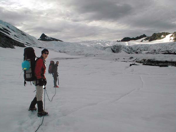
The next morning we started off up the Bonar glacier climbing to French peak then down to French Ridge hut. We hiked the length of the glacier, roped together with a kiwi coil to protect against crevasse falls. I was the only one to slip into a crevasse as I stood near the lip as the lip suddenly collapsed and dropped me knee deep into a crevasse. It was easy to escape this crevasse but it put me on notice to be careful to stand back from the edges of the deeper ones. The day was overcast which was good, it protected us from the ultraviolet light from the sun and it protected the snow on the glacier from the heat of the sun, walking up snow is much easier than walking up slush.
Walking down snow is easier still, once we reached the top of the glacier we got to glissade down a ridge then hike down rock to the newly built hut.
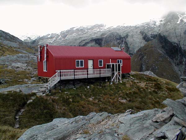
The hut sleeps 20 comfortably, has a well lit kitchen dining area, and has views up the local mountains and down into the nearby valleys. Waterfalls appeared in every view as high altitude glaciers melted in the summer sun and the resulting water obeyed the law of gravity.
The next morning we set off again. At first the trail was easy. But then it dropped off the edge of a cliff. We had to descend by grabbing roots and lowering ourselves down short rock cliffs. It reminded me of the Adams slide trail on Mount Adams in New Hampshire, the trail didn't switchback, it went straight up, or in our case down, the mountain.
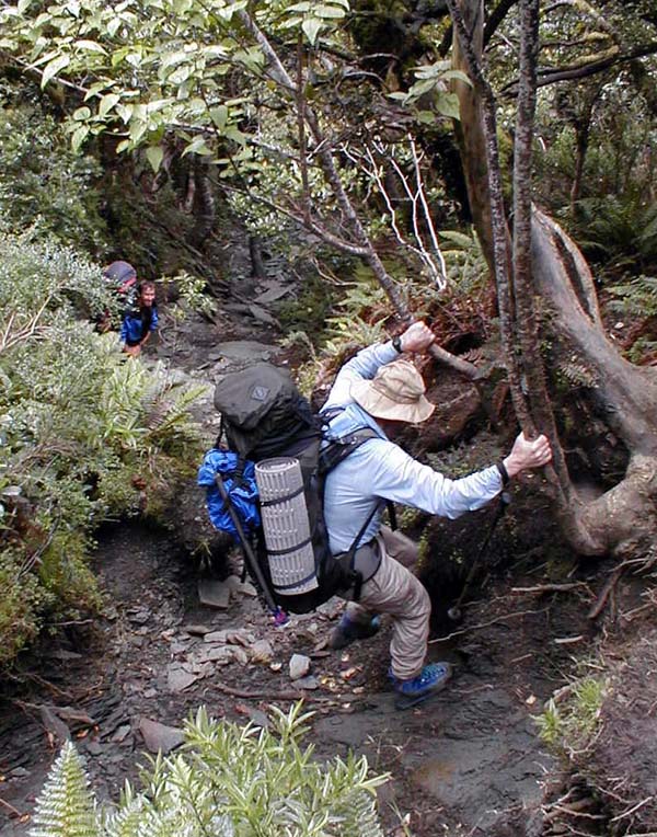
Climbing down the trail wearing full packs and plastic boots the trail was hard work. Actually, after three days of wearing plastic boots, they were beginning to feel normal. I could climb down tricky sections of trail in them and feel confident about my foot placements. After a couple of hours of descending, Bob caught a toe under a root and fell. This is a serious danger when wearing a pack. After a bit of a rest he seemed OK so we started again. A short time later Bob misplaced his left foot and fell again, this time rolling down a short cliff. We took a longer break this time to assess if he had injured himself. Bob seemed OK but when I suggested to Bryan that we carry Bob's pack down to the bottom of the route he immediately grabbed the pack and adding it to his own zipped down to the bottom. Both Bob and I were impressed that he could move so fast wearing two packs on this tricky trail. Without the pack Bob moved rapidly down. Later we found that Bob had slightly injured his ankle on the first fall which may have led to the second fall. Pecision foot placement is crucial on this steep trail especially when it is wet, as it was for us.
We rejoiced when we reached the river at the bottom of the descent.
From here we had a gently rolling trail leading us back to the trail end parking.
|
Scientific Explorations with Paul Doherty |
|
25 Feb 2002 |